Dispatch From the Sierra – This Year’s Snowpack

September marks the final month of California’s water year, and our state has certainly had an unusual one.  Much of our anomalously high precipitation came in a series of atmospheric rivers, often called “drought busters.” ARs are powerful westward-driven channels of water vapor that move fluidly, high in the atmosphere. This vapor often changes upon landfall, producing large volumes of rain or snow.

At home in Santa Clara County, we were cleaning up after each storm in ways we’d never before: clearing 20 palm fronds the roof, repairing a screen door ripped from its frame. By the end of February, statewide precipitation totals were at a 122-year high. Evacuations and failure risk at the Oroville Dam made national news, sparking discussion on California’s aging water infrastructure and development in floodplains. These same issues played out locally, as I watched Coyote Creek crest the Anderson Dam in my hometown for the first time in 11 years. It swelled as it flowed northward, closing U.S. 101 and flooding the Rock Springs neighborhood in San Jose.

News from the mountains was equally eventful. It seemed that years of seeing dire, winter-brown LANDSAT images of the Sierra Nevada in the news, and at scientific conferences, were suddenly erased. Sierra snowpack reached 164% of long-term averages by the end of March, and then it was 190% on May 1. Ski lifts were buried. Yosemite National Park’s Tigoa Road stayed closed until the end of June. In the lulls between storms, I joined crowds on parks and trails to see incredible displays of wildflowers. It was a superbloom you could see from space. California, it seems, does everything in extremes.

In April, I came to live and work in Sequoia National Park. With Kings Canyon, the two parks (known together as SEKI) encompass ~1350 mi2 and nearly 14,000 feet of relief. Our wet winter was something I could no longer monitor digitally; it became part of my everyday. Training and housing those initial weeks were based in Three Rivers, CA, while we waited for the snow to clear from the more established housing community at higher elevation. The forks of the Kaweah River run through and define this landscape, and Three Rivers is their convergence point. The Wukchumni people were the first occupants of the region, and up to 600 once occupied Hospital Rock year-round. Located on the Middle Fork of the Kaweah, Hospital Rock is situated among buckeye and oak trees – by all counts bountiful, and sacred. This spring, it was on the front lines of snowmelt.

MarbleFalls

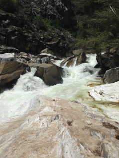
Marble Falls | April 30, 2017

Always driven to hike new trails and seek the highest altitude possible, I was restless and on edge those first weekends in SEKI. The weather didn’t cooperate with this goal when mist descended on the park, obscuring higher elevations with yet more snow. Trails around the Foothills section of the park were often hot, and dusty. Hiking to Marble Falls, I daydreamed of a lazy wade at my destination, perhaps some mist to wash sweat and sunscreen from my eyes. Instead, I discovered what it was like to see higher elevation snowmelt coalesce downstream, into torrents. It was powerful and dangerous in a way that didn’t invite lingering.

Hours later, an 18 year-old man drowned downstream. The local news seemed full of such drownings, and high flood alerts were issued for the equally dangerous Kern, Merced, and Tule Rivers. My hiking attempts always led to water; even the slightest creek traces were too risky to cross.

We finally moved to housing at 7000 ft in mid-May, and again I hit the trails, in hopes of quieter streams at higher elevation. I was wrong; streams were equally impassible, and late-season, hummocky snow was an added obstacle. Pooling water, downed trees, and getting turned around easily made for difficult terrain to navigate.

There was no choice but to wait it out. Nighttime temperatures dipped below freezing, and heaters smelled of last winter’s dust as they ran throughout the night. Among the staff, we spoke of longer days, swims in alpine lakes, hiking nearby summits. After experiencing warm weather and superblooms on hikes in Santa Clara and Monterey Counties all of March, it felt strange to watch and wait for spring to come again. It snowed yet again in June, the week before summer solstice.

LodgepoleSnowTry2

Lodgepole | June 12, 2017

Warmer temperatures and open trails did come at last, with brilliant displays of flowers that made the year seem like an endless superbloom. Snowmelt, meanwhile, never seemed to abate. Any discussion of Sierra ecology often mentions the dependency of flora and fauna on snowpack as a “water bank” that melts gradually throughout the summer. This season brought record-breaking heat waves, forcing melt that seemed anything but a slow release.

Tokopah Falls, Sequoia NP | May 13, 2017

Mist Falls, Kings Canyon NP | July 5, 2017

South Fork of the Kings River, Kings Canyon NP | July 19, 2017

John Muir once spoke of sourcing awe and energy from alpine places and weather. I understood this a little more as I watched the land drain its massive snowpack. But the words of NPS Director Jonathan B. Jarvis on climate change were with me, too: that “the reality of change seems to shout from the land.” As summer progressed, the news among staff and on park radio included more drownings in streams, and search and rescue resources stretched thin. Several record-breaking events were converging in SEKI: nearly double the snowpack, summer heat waves, high visitor numbers.  People died, many on vacation or their day off, while seeking beauty and respite in a national park.

It was about halfway through the water year that the state’s drought emergency was lifted. In Drought Monitor terms, no part of the state is in “exceptional drought” right now, compared to last year’s 21%. But one wet year doesn’t cancel out the dry ones that came before, or guard us against those to come. We may well be in a new climatic normal of deep drought, then deluge, in California. Is this how the land shouts the message? I now have one season of observations in a mountain community, just the start of understanding the answer to that question. I do know that bearing witness to the landscape during this water year has strengthened my storytelling, and resolve as a climate scientist.


Biodiversity on Earth Day 2016

I went to a fantastic event last night: Volunteer Recognition Night for L.A. Natural History Museums, hosted at the flagship. NHMLA knows how to host an event – the galleries were filled with catering stations, with all kinds of adorably-served delicious food. Nice to socialize with Page Museum staff and supervisors, and meet other volunteers – some of the kindest, most enthusiastic, hardest-working people I’ve been privileged to work and talk nerdy Pleistocene science with over the past 9 months.

We had full run of the entire museum and exhibits. I had the rare experience of having a few galleries to myself, something I always find awesome for a few moments, then unnerving as I contemplate the disappearing homes and habitats of so many now-taxidermied animals.

File Apr 22, 10 56 38

Are museums now mausoleums for Earth’s biodiversity?

Today is Earth Day. This comes at the end of a week that seemed packed with more-than-usual harrowing news for our planet. We just had the longest succession of hottest-on-record months (eleven). Mauna Loa’s station is about to reach and surpass carbon dioxide levels of 410 ppm…so soon after passing the 400 ppm global average threshold, less than one year ago. California-based hydrologist Jay Famiglietti wrote an op-ed about how our state “simply does not have enough water to do all the things that it wants to do.” We heard that 93% of the Great Barrier Reef has experienced coral bleaching, some of it irreversible. Biologists broke their usual scientific demeanor in media spots and swore, got angry, cried.

Frankly, everyday should be Earth Day. Today’s Paris Agreement is a hopeful move on the part of our politicians and policymakers, but change must come from all of us, and adjusting our expectations for what constitutes “the good life.” Are you doing anything to lessen your environmental impact today? What can you put into practice for longer than just one day?

Fire in the Mountains

I am fortunate to have hiked, backpacked, conducted research, and explored so much of the mountains and protected forest around Los Angeles for the past 4 years. More dry-adapted than other places I’ve lived, there is a strange tenuousness to the landscape here, particularly in the San Bernardino National Forest. I never seem able to take a nice landscape photo, without dry, dead trunks jutting into the frame, like so many bones:

IMG_0532

Last summer, a NYT article finally said what I couldn’t quite articulate: “For those who know fire, fuel is now all they see.”

Was it always this way? This is a big-picture question for much of my research. We know wildfire plays an important role in California landscapes — both for its inherent health, and at times of landscape change.

Charcoal counting is one approach for building a wildfire history for a locality, and perhaps the broader region. If conditions are right, charcoal will runoff into lakes, and accumulate over time. The MacDonald Lab is currently processing charcoal from about 4 different sites and projects, including ocean and lake cores, and marshes. I have been supervising charcoal digestion, counting and data synthesis on two cores from Big Bear Valley that span the last 100,000 years.

Digesting core material for charcoal analysis usually involves a sample for every centimeter of core, and a sample volume of 1 or 2 cm3. We used the protocol from the Limnological Research Center on Big Bear Lake, which had a record dating from 10,000 years ago until ~300 years BP. The history was fairly dynamic, and comprised a students’ course project over two quarters.

However, Baldwin Lake’s record is long, at ~27 m; faced with the prospect of ~2700 samples (!), we needed a more efficient way to process material. I adopted this technique: careful, continuous 1 x 4 cm slices, cut out at an angle to get ~2 cm3. Most of the Baldwin material is comprised of organic silts — very conducive to careful slicing:

IMG_0610

Nearly a dozen students, in total, helped with the laboratory prep of the samples. Two students earned research credits for counting Big Bear Lake, and another counted Baldwin Lake during Marine Isotope Stage 3 (about 57,000 – 27,000 ago). I set aside a weekend+ to power through the remaining counts – about 11 m of material – which was doable based on our prior knowledge of the site. I expected low counts. In fact, my go-to talking point about this site has been largely about charcoals absence — what did that mean for wildfire occurrence? Can a dry-adapted forest go for thousands of years without wildfire?

Twitter is a good complement to those solitary hours at the microscope. In fact, I seem to get biggest and most enthusiastic response to my iPhone ‘scope tweets:

I didn’t just get charcoal counts — going through the ~11-12 m of uncounted core, in sequence, was a useful exercise. It was a nice “tour” through the core I’ve spent so much time upon. I saw changes in mineralogy. Hornblende fragments were common, which can look deceptively like woody charcoal: shiny, black, dark, and blade-like. We have pXRF data that includes calcium, and I could definitely tell when I hit the areas that peak for Ca:

Charastems.jpg

I’d observed these spiral-shaped objects before, and finally IDed them. They are derived from Chara, or muskgrass…an aquatic plant that likes hard water. Chara often has calcified “rinds” around the seeds and stems.  Charles Lyell described, illustrated, and discussed their importance to the geologic record in Principles of Geology.

1835_Lyell_WS2.3_fig294Chara

“Gyrogonite, or petrified seed-vessel of Chara bispida.” Lyell (1835).

I also count/estimate charcoal fragments on pollen slides, which we interpret as the finer, wind-blown charcoal that traveled, airborne, to the San Bernardinos. That task is much slower going, but I still see “forms most beautiful” (and weird, and gnarly) on occasion.

Microcharcoal fragments at 400x magnification

We’ve now got a much more interesting — albeit nuanced — story about charcoal occurrence in the San Bernardinos, and the climatic conditions that likely promoted fire on the landscape. We have phases of quiescence, but also see fire rather reliably as a result of shifting paleoclimate. I’ll be talking about the first round of results at the American Association of Geographers annual meeting this coming week.

How to celebrate publication with cake

I thought I’d re-enter blogging with a storified version of how we celebrated the first peer-review publication of my labmate/roommate Kate Willis. I chose the celebratory medium of CAKE.

The paper (here) is in Biological Conservation, and it’s a review of ecological monitoring (mostly vegetation) in U.S. protected areas (e.g National Park Service, BLM-managed land, etc.) Kate is a single author, and B.C. has a respectable impact factor. In short, this is a B.F.D.!

We decided to host a manuscript party. The cake was intended as an homage to the paper. Since coastal sage scrub is so prevalent ’round here — especially in the Santa Monica Mountains and Channel Islands where Kate largely works — the cake recipe had to have fresh sage. I chose this apple-sage cake recipe. Turbinado as sweetener gave it a nice flavor.

Sage

Beautiful fresh sage

I had never shredded Granny Smith apples before, but even at the batter stage, results looked promising.

Batter

Cake batter, before cooking. Chopped sage, shredded apple, and turbinado yield a great flavor.

I baked, and waited. While waiting, an amazing smell began to permeate the apartment. I happily browsed and chose chapters for my spring seminar class “Fueling the Future” on energy resources. Evaluations from last year actually complained there was not enough reading assigned. So, we’ll be delving into Yergin this year.

Yergin

The cat looks skeptical.

At last, we had a perfect bake! Kate had made cream cheese frosting the day before. I made sure it underwent multiple taste tests and trials (like a good scientist). After confirming its tastiness under various conditions, I applied it to the cake. The turbinado-sage-apple-cream cheese was shaping up to be an awesome mix of complimentary flavors. I began to grow even more excited for the final reveal and tasting.

Slide1

Cartoon by Allie Brosh

Earlier in the week, I had invited people to our place Saturday night, promising other food, and the cake as the Main Event. I got a little slap-happy in the course of writing the email:

“There will be a celebratory cake, decorated according to the keywords of Kate’s paper. I’m not revealing more in the hopes this will entice you to come. Rest assured it will be awesome. In fact, it will have it’s own DOI.

“This will be followed by a dramatic reading of the paper.”

I definitely got a few “Dude r u joking” replies to this.

So now we had sage cake. I added other elements to deliver on my promise of themed decorations:

Slide2

The cake was well-received, and a hit. Hopefully Kate’s paper will similarly disseminate, get cited, and we have thus marked the start of a promising h-index.

Heart Lake Logistics

Previously, I posted about my experience backpacking in the Heart Lake Geyser Basin in Yellowstone National Park. It required much planning in terms of gear, our itinerary, and registering with NPS. The hard work was worth it, though. So, here are some resources we used for our visit.

Our first criteron for a backpacking spot was a place where we could safely chill out in some geothermal water. While the Bechler area in the southwest corner of the Park has this is spades, the trailhead for the Heart Lake Geyser Basin is more accessible. It’s trailhead 8N1 located just off US 191/287 in the southern section of the park, on the eastern side of the road (across from Lewis Lake).

Our second criterion was something that could be done as one overnight, in the range of 15-20 total miles. This was just enough distance to hike in one day and finish before sundown. We felt we’d “gotten away from it all,” without pushing ourselves too hard to cover some ridiculous injury-inducing daily mileage. The trails continue around the lake, however, and onward to the Continental Divide Trail, so a multi-day trip is possible.

There are descriptions of this hike online, including this great Backpacker magazine document. It has a map, profile, and is formatted as an infographic. This visual format is very concise and, if printed out, portable. It includes the side trip to climb Mt. Sheridan, which we didn’t do.

For my part, I found the Lonely Planet:Yellowstone guide book most useful during the trip. In the Park, it was great to have a resource that didn’t depend on WiFi or cell connectivity, and we used it to find other (non-backpacking) sites and activities. Looks like the .pdf version for a tablet, etc. is a steal at $3.49.

We used National Geographic map #201 for Yellowstone while backpacking. It shows topography and much more detail than the NPS-issue park map/brochure.

The NPS process for obtaining your backcountry permit is here. There are a handful of backcountry permit offices throughout the park, and you must visit, sign waivers, watch a safety video, and have your dates and destination in mind. As described in my previous post, the backcountry is staffed and they will check on you at your assigned campsite. It’s the most strict process I’ve experienced, but not unreasonable. Restricting the flow of backcountry visitors meant that we saw few people, and were able to have a memorable wilderness experience for a couple days.

My favorite “primer” on of the local ecology is here, at the Yellowstone wiki.

Happy trails!

Katie
Los Angeles, CA

Last week, I wrote a post about my five favorite popular press articles from the past year.  I felt the following were noteworthy as well and are great resources.

Organized by topic, in no particular order:

Wilderness:

How Chris McCandless Died” by Jon Krakauer, The New Yorker, 9/12/13
Absolutely riveting story of Krakauer teasing out the health effects of McCandless’s meager diet. It’s also a reminder of how mysterious the field of botany remains, at times. We can describe all the plants, but how much do we really know about all of their effects on and interactions with the human body?

Climate Change:

Climate change our most serious security threat” by Michael Breen, SF Gate, 08/23/13
Here, the author recalls his own deployment to Iraq, where our over-dependence on fossil fuels and the weather extremes of climate change, were especially amplified.

How Much Will Tar Sands Add to Global Warming?” by David Biello, Scientific American, 01/23/13
Straightforward breakdown on the potential impact of burning this inefficient fuel source, if total extraction and production were to proceed.

Hydraulic Fracturing / Fracking – Dakotas:

A Mysterious Patch of Light Shows up in the North Dakota Dark” by Robert Krulwich, NPR News, 01/16/13
Using a series of NASA satellite images, this article illustrates the light pollution of ND oil fields that is now visible from space.

North Dakota Went Boom” by Chip Brown, New York Times, 01/31/13
Great piece describing the extent of landscape, economic and social transformation currently occurring in North Dakota.

Hydraulic Fracturing / Fracking – California:

Vast Oil Reserve May Now Be Within Reach and Battle Heats Up” by Norimtsu Onishi, New York Times, 02/03/13
Published right on the heel of “North Dakota Went Boom,” this was the first I’d heard about the true extent of the Monterey Shale. I was gobsmacked by the possibility that reserves may be “four times…the Bakken Shale in North Dakota.”

California Legislature passes fracking regulation bill” by Marc Lifsher, Los Angeles Times, 09/11/13
Despite some environmental groups withdrawing support after this bill passed, this is a start towards (previously nonexistent) regulation.

‘Fracking’ the Monterey Shale – Boon or Boondoggle?” by Alex Prud’homme, Los Angeles Times, 12/29/13
Great Op-Ed on the possible over-estimation of oil reserves, current state of regulations stand, and complexity of issues and stakeholders involved.

Land Use:

Land transformation by humans: A review” by Roger LeB. Hooke, José F. Martín-Duque, and Javier Pedraza, GSA Today, December 2012
One of the best, most concise summaries of land degradation I’ve read, with a great collection of references to important works and scholars.

Population:

Our Overcrowded Planet: A Failure of Family Planning” by Robert Engelman, Yale Environment 360, 06/24/13
Female empowerment and education is a running theme of Engelman’s articles on population control. I recommended this to my “Global Environment” students this year as a complement (and, update) to Hardin’s “Tragedy of the Commons.”

Hungry Planet: What the World Eats,” photos by Peter Menzel, Time, 09/20/13
Amazing photo essay of families around the world, with a week’s worth of food and drink spread out, with cost listed in dollars. This was started a few years ago, but had an update in September.

Paleoclimate/Paleoecology:

“The Lost World,” [2 parts], by Elizabeth Kolbert, The New Yorker, 12/16/13 and 12/23/13.
Fantastic story of old-school paleontology and the how the idea of extinction evolved [Part 1], and discussion of whether or not we’re witnessing – and causing – the next large extinction event [Part 2]. Unfortunately these are behind a paywall.

What Killed off the Woolly Mammoths?” by Jennifer Abbasi, Discover Magazine, 09/09/2013
A summary of the complex suite of climate (and possibly anthropogenic) factors that led to the demise of the mammoth, based on work my advisor (Glen MacDonald) recently conducted.

Ecology:

Who Will Speak for the Bees?” by Katie O’Connor, Conservation Biology Institute Blog, 09/16/13
This post is about an unfortunate, and unintended loss of a bee population in Oregon. It reminds me of Muir’s quote on ecosystems: “When we try to pick out anything by itself, we find it hitched to everything else in the Universe.”

Megadrought in U.S. Southwest: A Bad Omen for Forests Globally” by Caroline Fraser, Yale Environment 360, 06/20/13
Discussion of fire ecology, and inevitable extreme wildfires that are predicted to occur with widespread warming and drying in the Southwest.

Yosemite Fire Puts San Francisco on the Front Lines” by Glen M. MacDonald, SF Chronicle, 08/29/13
Written by my advisor, this article mentions how the Rim Fire threatened Hetch Hetchy water supply. A good reminder of just how dependent our urban centers are on seemingly-distant wilderness areas, and the ecosystem services they provide.


Katie
Los Angeles, CA

Britten Leigh Photography: ScienceRocks &emdash;

Other 2013 Fave Articles

Favorite Articles I Read in 2013

Most of the popular press articles I read focus on geoscience and environmental issues. When I read damn good writing in the journalism milieu, it stays with me and I want to share it with anyone who will listen.

To that end, I compiled a round-up of my favorite articles from 2013. These are the ones that I go back to for re-reads, that reinforce why I do the work that I do, that inspired new directions in my research, or that were so compelling or haunting they stayed with me.

The finished list certainly has topical biases, reflecting my particular interests over the past year. General themes include wildfire ecology, domestic fossil fuel extraction, and my research discipline: paleoclimatology. The allure of past worlds, climates and landscapes is still quite strong for me.

1. “Into the Wildfire” by Paul Tullis, New York Time Magazine, 09/22/13.

Wildfire is one of the most critically important issues for the ever-warming, ever-growing West. Literature on fire ecology is voluminous; Tullis gives a great distillation here, and interviews top fire scientists. Jensen and McPhersen (2008) wrote, “…very little meaningful information ever filters beyond the realm of wildfire experts to the general public, or to academics and experts in other, even closely related, fields.” Tullis’s article does much to bridge that gap.

2. “Why I Came to Washington to Protest the Keystone Pipeline” by Rick Bass, Yale Environment 360, 02/15/13.

It’s telling that a retired petroleum geologist wrote this call to protest. Lyrical yet logical, this is my favorite piece on “the folly of the proposed Keystone XL pipeline.” He describes imagining the millions-of-years old marine landscapes that can, given the right conditions, lead to oil trap formation. One senses that barrier between this world and those past beaches because near-porous for him, an experience I’ve had myself during archaeology or geomorphology fieldwork. I’ve also done fieldwork in the Alberta taiga, undoubtedly the most pristine landscape I’ve ever seen. Bass makes a compelling emotional appeal to protecting this boreal forest, describing it as “the great lungs of North America, one of our last hopes for temperance against rising CO2 levels.”

3. “For 40 Years This Russian Family Was Cut Off From Human Contact, Unaware of World War II” by Mike Dash, Smithsonian.com, 01/29/13.

A fundamentalist Russian Orthodox family fled persecution in the 1930s into the Siberian forest, where they eked out an isolated living for decades. This haunting read details how a team of prospecting geologists came to find them in the 1970s, and how they gradually learned the family’s story and struggles to subsist deep in the Siberian taiga for so long.

4. “How High Could the Tide Go?” by Justin Gillis, New York Times, 01/21/13

This article should be required reading for any climate skeptic…or hell, any citizen of the world. Gillis illustrates why paleoclimate research matters, and the real threat of sea level rise to our coastlines. In addition, I love that he opens the article with an account of a fieldwork expedition. Fieldwork among other driven, enthusiastic geoscientists is a unique experience, the day(s) filled with a relentless drive to seek the next core, the next fossil, or the next outcrop before sundown. Highlighting the importance of the scientists’ work here (documenting Pliocene sea level rise) adds even more urgency.

5. “Thank You For Fracking” by Tom Chiarella, Esquire Magazine, January issue

I took “Intro to Creative Writing” from Prof. Chiarella, and I remember getting impatient that semester with the amount of time I had to spend writing stilted, awkward poems, rather than prose. When his lines here lean towards the overwrought (“when [the gas is] gone, we’ll look for more — deeper in the earth, at the bottom of the ocean, in moons, in the sun, probably in the stars…”), I’m reminded of that class.

And yet, the language kind of works; I love the title, for starters. What follows is a nuanced piece on the natural gas boom, the sheer power of the technology, and its effect on the lives of real people in Marcellus Shale country. I identify with a duality expressed here: deep concern with the fast expansion, regulation roll-back, and lack of industry transparency, and yet a love for visiting drill sites, and seeing firsthand how the extraction process works.

There are many other great articles I’d love to list and share, but for the sake of brevity, I’ll do that in another post.

Katie
Carmel, California

John and I went to Teton and Yellowstone National Parks, and visited many of the popular sites: Old Faithful, the Grand Canyon of Yellowstone, and Jenny Lake. But the most memorable thing we did was an overnight backpacking trip in the Heart Lake Geyser Basin.

The first 4-5 miles was through a rather open forest, with lots of old, burned logs and short pine trees. Interpretive signs described this area as ravaged by the 1988 Yellowstone fire. I like mysterious old-growth pine forests, so while it was cool to see the forest regrowth, it still struck me as a little strange and sad. Sad, that the old forest was gone and would not regenerate in my lifetime, and strange that it was such an open, sunny landscape, often with grasses and wildflowers, and stunted-looking trees dispersed throughout. Groundcover included snarls of old, burned logs and other debris.

I later learned that the forest is dominated by Pinus contorta (lodgepole pine). The bedrock is rhyolite, one of the most quartz-rich and explosive of volcanic rocks. Rhyolite’s mineralogy is rather depleted and cannot support most arboreal species, but lodgepoles are drought-adapted, with shallow roots, and thus create large swaths of monotypic forest in parts of Yellowstone. Lodgepoles are also wildfire-dependent for their reproduction and for stand-thinning. This makes for large tracts of homogeneous forest that are comprised of a flammable tree species and accumulating ladder fuels. Wildfire, then, isn’t a matter of “if,” but “when.”

The 1988 Yellowstone Fire was significant, burning over 1.5 million acres, 800,000 of which were within Park bounds. During its early stages, modelers predicted what its extent would be in two weeks; the fire overtook that predicted area in just one day. At the time, it was believed that the soil and ground had been absolutely sterilized by this high-intensity burn. Seeing new sprouts and recruits the following spring was a surprise to Park staff and ecologists alike. The area has now been well-studied, and we understand much more about wildfire ecology in the West.

All this made for one of the strangest landscapes I have ever passed through, especially after a small pass about 4-5 mi into the hike. We had seen no geothermal activity until this point, and suddenly had an expansive view of several burbling, steaming geysers, and Heart Lake — our destination — in the distance. We descended from the pass:

YS2

We finally saw a small, quiet ranger’s cabin at the shore of Heart Lake. Something about walking on the gray beach of this lake gave me an intense feeling of remoteness. I felt like we had just landed on the surface of the moon, or washed ashore onto a deserted island.

YS3

I misread our campsite number on the permit, and so we continued to hike farther and farther along Heart Lake’s perimeter. Eventually we left the shoreline, and ascended slightly about 100-200 feet above the lake’s edge. The terrain was irregular and undulating, with a steep descent to the water. Once-glaciated mountains were to the west, including Mount Sheridan. The steep drop and the hummocky surface signaled to me that we were crossing a series of old moraines. The glaciers are long since gone, and the surface of these features have stabilized (somewhat) and now host vegetation. It was some rather exciting geomorphology to me, even if it meant we were off-course and overshooting our eventual campsite.

YS4

Ultimately, we backtracked to our rightful campsite, which was a good thing, because the backcountry rangers diligently come ‘round every evening and ask for permits. We were about 20 yards from the shore of Heart Lake. While wading in the lake and cleaning up from the day, I heard a splash and saw 5 small heads start moving in the water. They were river otters! They noticed and swam towards us, bobbing in the water and making (threatening?) calls at us, before they swam off. It was such a cool wildlife encounter as evening settled over the lake.

We awoke to fog the next day, and waited for the sun to emerge and dry our gear. We spoke to the ranger on our way out about where in the geothermal area we could swim, and he directed us to Witch Creek, about 2 miles back toward the pass. Park rules state you can only soak in water bodies that have a current. So we did this, and it was amazing to take off a heavy pack, and relax in a natural, flowing “spa.” Every backcountry trip should come equipped with a natural “spa,” to help work out all the tension in the back and neck!

One of the allures of backpacking for me is the experience of traversing a landscape, with time to observe the changes in vegetation, terrain, and geology. This was one of the most unique backpacking trips I’ve done. I enjoyed the shared experience with John, and had never seen so many earth processes at close range that all interplayed to create this landscape of geyser activity, wildfire scars, and glaciation.

Want to make this trip? See my next post on guides, maps, backcountry permits, and other resources.

Katie
Los Angeles, CA

YS5

Heart Lake Backpacking